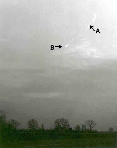
This is one of the photos used by astronomers Von Del Chamberlain and David J. Krause to triangulate the trajectory of a large fireball with a smoke trail that passed near Detroit, Michigan and Windsor, Ontario, at 4:43 p.m., December 9, 1965, The results were written up in the Journal of the Royal Astronomical Society of Canada(RASC) in 1967.
The photo was taken near Pontiac, Michigan, about 20 miles north of downtown Detroit, and shows the smoke trail after the fireball disappeared following an explosion. Point B at the end of the trail was thought to be the puff of smoke created by the final explosion. Supposedly this photo was taken within about a minute of the end of the event. Point A is a kink in the trail also visible in another photo taken about 8 miles west in Orchard Lake, Michigan. These two points were what was used for triangulating a trajectory.
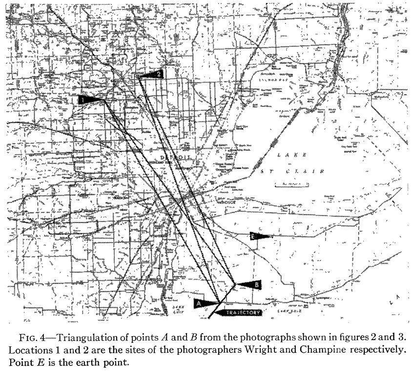
The triangulation diagram from the RASC article is shown directly below, noting the location of the two photo sites (1 & 2), and the two triangulation points in the trail (A & B). The authors claimed the triangulation showed the fireball trajectory ran from the Southwest to the Northeast (dark line between points A & B)
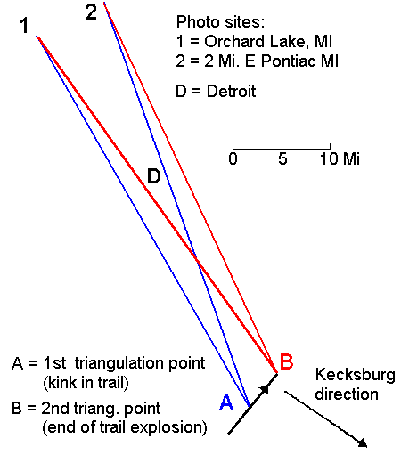
This is a working diagram of the triangulation that I lifted directly off the above graphic.
This fireball was also associated with something that came down at practically the same time in Kecksburg, about 240 miles distant. Note that the straight-line direction to Kecksburg is practically at right angles to what the RASC article claimed was the true fireball direction. If that was the case, then obviously the fireball couldn't have anything to do with Kecksburg. It would be just an amazing coincidence.
But just how reliable and accurate was the triangulated trajectory in the RASC article?
A Prelimary Analysis of the "Kecksburg UFO" Fireball Trajectory and Possible Error
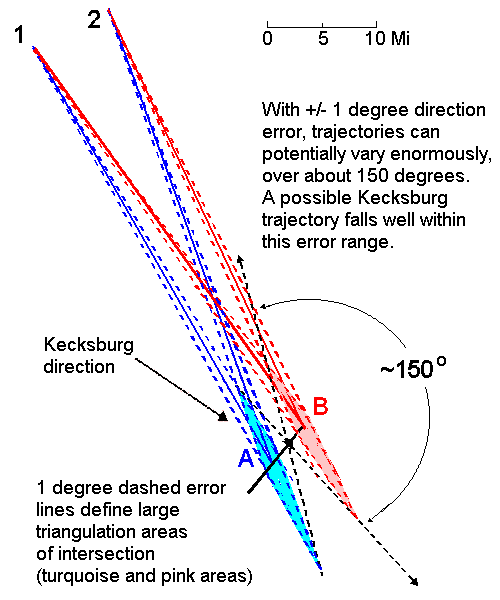
A huge problem with the RASC article was no included error analysis. Note that photo sites 1 & 2 are relatively close together compared to the distance to the fireball trail (A & B), creating a narrow triangulation base. This diagram shows the possible effect of 1 degree of error in determining the directions of points A & B. As a consequence, the resulting trajectory instead of being well-defined can instead vary over about 150 degrees!A Kecksburg trajectory would fall well within this error range.
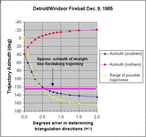
The graph immediately below shows a more quantitative analysis of the effects of differing direction errors on final trajectory. This was done using basic high school Algebra and trigonometry (plus an Excel spreadsheet) to determine intersection points of the error lines and the range of angles of possible trajectories that can result.
As can be seen, the range of possible trajectories increases very rapidly even for very small errors in determining directions of less than +/- 0.5 degrees. In fact, a straight-line trajectory to Kecksburg is still just accommodated with an error of only +/- 0.4 degrees.
There are other possibilities as well if one assumes the fireball could have been a controlled spacecraft of some kind and could change trajectories, just as the space shuttle does to some extent during re-entry. E.g., if the Detroit-Windsor trajectory was directly West to East, or azimuth 90 degrees, this could be accommodated with only +/- 0.25 deg. error. Perhaps later a turn was made towards Kecksburg (pure speculation).
Another possible indication that the RASC trajectory is in error can be seen by examining the photo above. The trail near B is noticeably thicker than most of the trail approaching A (except in the "puff" at A where the trail ends). A straightforward explanation of this would be that the trail near A is much closer to photographer 2 than the trail at B. In other words, the trail is steeply slanted away from the camera (the fireball was moving off into the distance) instead of being at nearly right angles, as the RASC article has it. If the RASC trajectory were correct, one would instead expect the smoke trail to be of about even thickness between A and B, since the fireball would be moving sideways to the camera and maintaining about an equal distance at all times.
This also has important implications for the steepness of the trajectory. The RASC article has the smoke trail diving toward the ground at a 52 degree angle relative to the horizontal. The altitutde at point A is 20 miles and about 5 miles away at B it is about 14 miles.
In contrast, if the object was moving away instead of sideways, part of the dip in elevation angle for point B is due to the object being further away from the camera. In one preliminary calculation assuming a "Kecksburg-directed" trajectory, the object instead descends half as much, from 18 miles down to 15 miles over 6 miles of travel, for an angle of 26 degrees to the horizontal, or half that of the RASC article. This is still too steep to get to Kecksburg (the object would impact only 30 miles further away at this rate of descent). On the other hand, one scenario could be this wasn't the main object but a piece that splintered off it. Another possibility, if the object had controlled flight, is that it could level out at lower altitudes, just as the Space Shuttle does at times as it comes in for a landing.
Sources of potential error in the RASC article are numerous and include tiny errors in reading compass directions in on-site surveys or not locating the exact sites to within inches of where the photos were taken during the same surveys.
There was also an assumption that the smoke trail didn't shift significantly between photos (photos were separated in time by about a minute), yet the smoke trail is obviously twisted, even in the other photo (not shown) supposedly taken within seconds after the event. This could indicate significant high-altitude shear winds causing the trail to depart quickly from straightness. If that was the case, then the locations of points A & B were not the same in photos 1 & 2.
As an example of how subtle this could be, the distances from the photographers to the midpoint of the smoke trail is on the order of 45 miles. 1 mile lateral change in position represents about 1.25 degrees. If the two used photos were taken 1 minute apart and winds were shifting the relative positions laterally of points A and B at 20 miles per hour, or 1/3 mile in the minute difference, this would represent an angular shift between A and B of about 0.4 degree, about half of what would be needed to sent the fireball on a trajectory headed straight for Kecksburg. This is also on the order of the thicker widths of the smoke trail. Casual inspection of the multiple photos taken would not necessarily detect this subtle shift in positions, if it did occur. A detailed analysis of all the photos would need to be done.