A copy of the video was allegedly smuggled out by at least one of the employees and eventually sold to Hard Copy and Sightings TV shows. (Both were programs of Paramount Studios.) Short segments were first publicly shown by Hard Copy Feb. 17, 1995 (video). Sightings subsequently aired additional footage December 10, 1995, in a report entitled "Intruder on the Range" (video). They also were more thorough than Hard Copy, hiring experts to do video analysis of the object and flight characteristics.
Updated material
I extensively reanalyzed the Nellis UFO data in 2004 in preparation for the 2004 Ozark UFO Conference (interview) and this writeup reflects what was learned. Because of the extended length of this new writeup, it has been divided into three parts:
This introductory part deals with where and when the S-30 and S-13 videos were made, including maps of the area, and some other background material, such as the inability of range operators to identify the objects.
Part 2 deals with the methods used in reanalyzing the S-30 video and the results, presented in graphs, an animation, and a discussion of S-30 UFO characteristics. Less detailed graphs and discussion of S-13 characteristics are on a separate page.
Part 3 (still being written) will be a more speculative discussion of UFO flight physics and theories of origin.
There had been a lot of conjecture as to exactly where the filming had taken place, and even whether it was at the Nellis Range. In an earlier version of this essay, I had noted that maps indicated an Area 13 lay within the fabled Area 51, or Groom Lake complex, where the U.S. has tested top-secret aircraft, like the U-2, SR-71, and Stealth. Similarly an Area 30 existed in the northwestern corner of the Nevada Test Site. However, it was unclear whether these were the same as S-13 and S-30, or subdivisions of other areas.
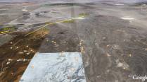
Very recently, Martin Powell has done some excellent scientific sleuthing and pretty much proven that the topographic profile of Black Mountain exactly matches what can be seen in the video. . Powell also dug up a photo showing the two radar domes on top of this mountain. As Powell points out, demonstrating that the video actually was shot within the Nellis Range area adds to its authenticity.
Powell was also able to determine from topography and overlaid bearing data that the mountain with radar domes was about 21 miles distant and to the southwest of the camera and radar. (More on exact location below)
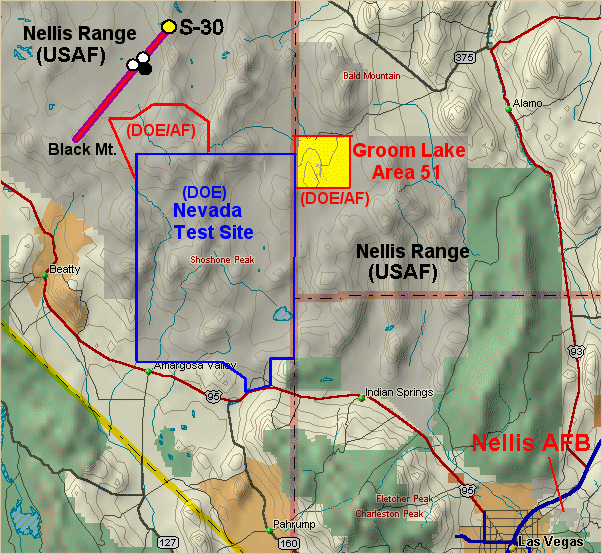
This places the actual site in an area sandwiched between the Nevada Test Site to the southeast, controlled by the Dept. of Energy, and the Nellis Range proper to the north and west, controlled by the Air Force. Part of the area in question is jointly controlled by both the AF and the DOE. (The fabled Area 51 to the east is likewise jointly controlled and sandwiched between the NTS and Nellis Range.) For a more detailed map of the area showing positions of the various sites relative to S-30 and Las Vegas click on the thumbnail map at right. The area under joint control is outlined on the map in red and contains numerous underground nuclear test facilities. A new section below points out just how close the UFO was initially to these nuclear test areas.
Strictly speaking, the area of the videos is not the Tolichna Peak Electronic Combat Range proper, which is immediately to the West. However, it is a part of a larger electronic warfare aerial training complex which includes TPECR and the similar Tonopah Test Range further to the north. (For a more detailed description and map, see Tom Mahood's Website.)
These are semi-secret areas that function to train combat pilots through simulation of air and ground combat conditions. The video is thought to have come from a threat radar, a simulated enemy radar site which pilots attempt to destroy or evade. Cameras are attached to the radar to later provide pilots with feedback on their performance.
While there isn't sufficient information to get a location of S-13, S-30 lies on the eastern portion of Gold Flat near the base of Quartzite Mountain. Powell also describes how S-30 lies "on the boundary between Ranges 74 and 75E, which are used for bombing and gunnery training on 'high value high threat targets'." He adds that the S-13 and S-30 designations probably don't refer to actual areas but are more likely locations of tracking radars, the "S" possibly standing for "site" or "station."
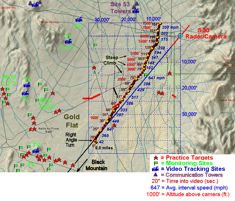
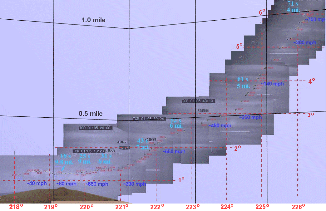
Click on the thumbnail at right, showing a more detailed topographic map of the Gold Flat area, indicating the likely position of S-30 and surrounding bombing/gunnery targets, camera sites, monitoring stations, communication towers, etc. Most of these were taken from 1988 USGS topo maps of the region. Also superimposed on the map is the calculated ground trajectory of the S-30 UFO, along with time into video, and calculated altitudes and average speeds in various intervals. A great deal of information is contained in this one graphic, such as the UFO first being spotted about 10 miles from the radar/camera, the UFO's trajectory being almost directly toward S-30 before veering off and approaching to within about 2 miles, and the UFO having a very erratic speed.
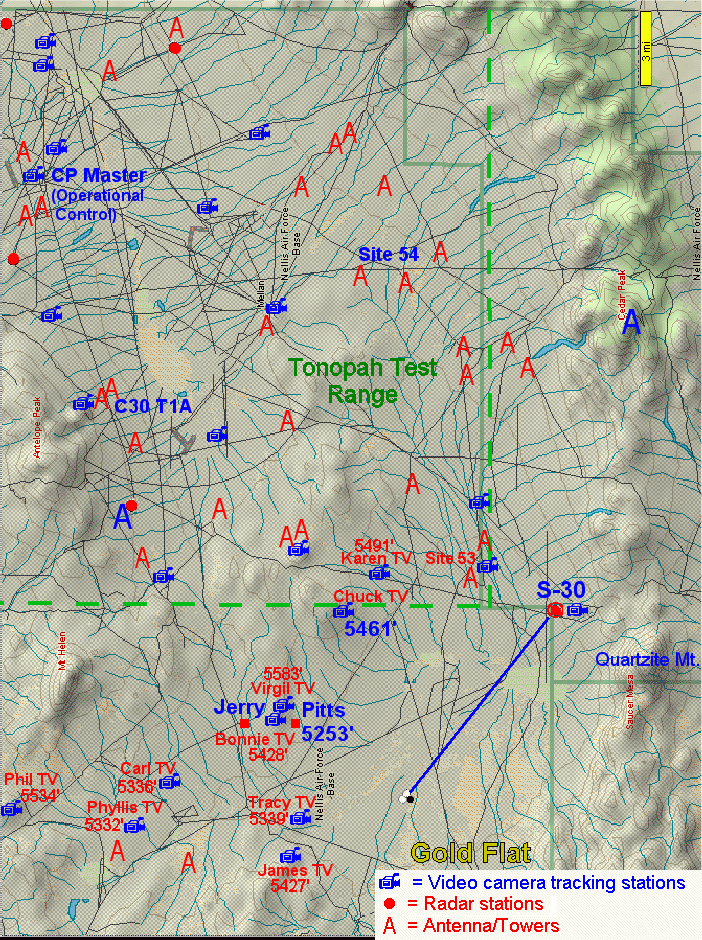
I also recently listened closely to the audio portions of the S-13 and S-30 videos and compiled new, more complete transcripts of range operator conversations. (S-30 transcript and audio, S-13 transcript and audio). There are additional clues in the transcripts pointing to the Nellis Range origins of both video segments as range operators call out the names of various range sites. E.g., at one point an S-30 operator requests the call sign of the unknown object. He's soon given the cryptic response, "Jerry answer--it's not at Com/Con." When I finally got detailed USGS topo maps, it turned out that "Jerry" probably referred to a complex of targets and stations ("Jerry 1, Jerry 2, etc.) about 13 miles west of where Powell pegged the S-30 site. (Click on thumbnail at right for map of Tonopah Test Range showing various camera, radar, and communication sites, with named sites in blue.)
Similarly in the S-13 video, controllers and operators are calling out other locations like "CP," "T1 Control," and "Target 54." "CP" likely corresponds to "CP Master," the main complex of buildings on the Tonopah Test Range (TTR) about 30 miles NW of the S-30 site and the center of operational control and telemetry. "Target 54" may correspond to "Site 54," a smaller complex of buildings and probably one of the main communication centers, about 15 miles East of CP Master and 15 miles NWN of S-30. And "T1 Control" may be the C30 T1A communication station about 10 miles south of CP Master and 20 miles WNW of S-30.
Relation to nuclear tests (New!)
When I recently examined the S-30 area with Google Earth, it was immediately obvious that numerous underground nuclear tests dot the region just to the southwest of the UFO's position at the beginning of the video. In fact, the closest of the these was only about 6 miles from the UFO, and about two dozen are within about 10 miles (which is only 2 minutes of UFO flight time on the video). Altogether, there are over 40 underground nuclear tests within 15 miles of the S30 UFO marked on the map I compiled from Google Earth. (Click on thumnail at right to view map.)
It was noted as far back as 60 years ago that UFOs seem to have a high interest in areas associated with nuclear weapons, such as Los Alamos, N.M. (design center), Sandia Base (Albuquerque), N.M. (assembly and storage of nuclear weapons), Alamogordo, N.M. (first nuclear test), Roswell, N.M. (first atomic air base), Fort Hood, Tex. (nuclear weapons storage facility), and Oak Ridge, Tenn. (manufacture of nuclear fuel). Numerous other incursions in nuclear areas have been documented since then, perhaps the most famous being the 1980 Rendlesham, UK incident(nuclear base and weapons storage facility). Researcher Robert Hastings over the last 30 years has documentednumerous incursions over U.S. nuclear weapons storage facilities and missile sites. Similar incursions are also known to have occurred in the Soviet Union. (one example)
Thus the presence of an anomalous, unidentified craft in close proximity to yet another nuclear test facility would be keeping with a long history of UFO interest in our nukes.
Exact location of S-30
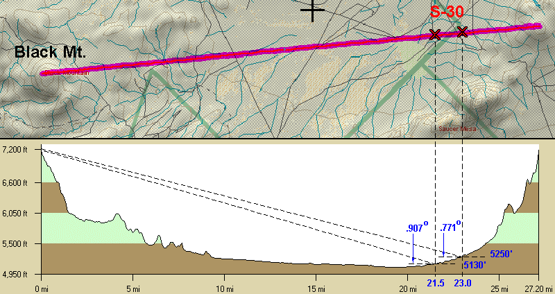
The precise location of site S-30 can be triangulated using the azimuth and elevation angles marked on the video to the peak of Black Mt. While simple in principle, problems arise in trying to determine the angles as the camera/radar tracks the unknown. The angles are displayed as whole numbers and the approximate "boundaries" of the angle markers can only be deduced when the overlaid azimuth and elevation change during tracking.
Based on a montage of dozens of overlapping video captures with Black Mt.in the background (thumbnail right), I was able to determine more precisely where the angle boundaries occurred (see more on this in second part of this write-up). From this I found that the peak of Black Mt. lay at an azimuth of 219.4 +/- .05 deg and an elevation angle of .775-.840 deg. By comparison, Powell also estimated the azimuth at 219.4 deg., but he pegged the elevation angle at a larger 0.92 deg. As will be seen below, his larger angle had the effect of moving the position slightly closer to Black Mt.
My Topo USA program is capable of doing cross-sectional profiles of terrain. The one below shows a profile through the peak of Black Mt. along the 219.4 azimuth. Using this data, it is possible to compute the angular elevations for a given distance and altitude, two of which are shown on the graphic. One is at 21.5 miles from the mountain showing an elevation angle of .907 deg. close to what Powell used for the elevation. The other is at 23.0 miles and an angle of .771, close to the lower limit that I set for the elevation angle. S-30 lies somewhere in between these two extremes.
THE NELLIS RANGE UFO VIDEO
by David Rudiak
Updated on: March 2, 2024
Overview of S-13 and S-30 videos:
Range operators don't know what the unknowns are
The commentary by range operators on both the S-13 and S-30 video segments indicate that nobody, including central controllers, knew what the unknowns were, despite the entire range being heavily monitored by radar and video and normally secure against intruding traffic.
S-13 Video
The S-13 segment is the least interesting of the two. From the radar data, the UFO was approximately 7 miles (11 km) north of the radar, moving in a straight line to the right at approximately 90 miles/hour (150 km/hr) at an altitude of 11,000 feet (3500 meters) above radar. (Graphs)
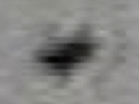
Unfortunately, the video shows no more than a distant, indistinct blob. The most significant part of the video is the sound track of the various range operators and controllers trying to identify the unknown object. (audio and written transcripts) Attempts were made to identify the unknown. Statements included, "T1 control doesn't know," "No ECM [Electronic Countermeasures], no tactic [tactical?]." These latter statements may indicate the craft lacked a known military electronic signature.
What's odd about this is that access to this combat training area is highly restricted, being heavily monitored by both radar and video, yet nobody, from operations and central control on down, had any idea what the object was or where it came from. The object wasn't one of their aircraft, and it is unlikely that a civilian aircraft could have wandered in initially unnoticed.
Another seemingly interesting portion of this video are statements by one of the Range operators that they had an unidentified and would launch an intercept missile "and see what happens." Twenty seconds later he announces, "We have impact." Ten seconds after this he states, "We'll call this a kill."
However, according to the second Sightings paperback book (Sightings: UFO), this surface-to-air missile strike was simulated, not real, and common practice at the Range where they routinely practice launch procedures against enemy aircraft.
S-30 Video
Visually and dynamically, the S-30 segment is far more interesting. The range operators can also be heard with excited voices trying to figure out the object's identity. Obviously it had them puzzled. One of them allegedly interviewed by Sightings with his identity concealed, claimed it was not a craft known to them and performed in a manner unlike anything he had seen before.
Time and Date
According to the time stamp, the time on the S-30 segment was 40-50 minutes before the S-13 segment (but possibly not on the same day). Although the time shown was about 23:20 hours, military radar is standardized to Zulu, Universal, or Greenwich Mean Time. Therefore, rather than being taken around midnight by infrared camera, as has been suggested by some (see e.g., Desert Rat #22), the video was apparently shot 8 hours earlier in daylight around 15:20 hours or 3:20 p.m. PST.
Originally, according to the December 1995 Sightings TV program (then on the Fox TV Network), the video dated to November 1994. In the more recent Sightings: UFOs book, the date was changed to late September 1994. However, the position of the sun, as indicated by lens flare in the video, is more consistent with a late October/early November date. (The flare, of course, also clearly indicates the filming was done in daylight.)
Considerable flare appeared when the camera was pointed at an elevation of 15 to 17 degrees and an azimuth of about 233 degrees. Taken together with the time on the video and the latitude/longitude of the Nellis Range, this corroborates that the video was taken around November 1. E.g., planetarium programs show that on November 1 at 15:20 hours, the sun would have been located at about 14.7 degrees elevation and azimuth 238.5 degrees at the Nellis Range, which would likely account for the observed lens flare. A week earlier, the sun would have been at an elevation and azimuth approximately 1.5 degrees greater, while a week later both would have been about 1.5 degrees less. However, the sun's position on Sept. 30 would have been at elevation 24 deg./azimuth 246 deg. Therefore, to account for the lens flare, it is likely the video dates somewhere between the last week of October to the first week of November, not late September.
Martin Powell has recently done his own independent analysis of the date, also based on the observed flare. He agrees that the video could not have been shot in September, but places the date to about a month later than I do, in late November or early December.
However, when I reviewed weather data from the closest published newspaper (Tonopah Times and Goldfield News) plus the Las Vegas Review-Journal, it showed that temperatures plummeted starting November 9 and mountain snow began. Tonopah at 6000 feet received about 1 foot of snow between Nov. 20 and 25 and temperatures averaged below freezing for the duration of the month. Black Mountain at 7200 feet would have been even colder with presumably even more snowfall, yet there is no indication of snow on the mountain in the video. Thus if the video was indeed shot in 1994, the lack of snow suggests the video was shot in early November when temperatures were still mild.
PART 2: Methods, Graphical Analysis, S-30 UFO Characteristics
The above graphic includes corrections for Earth's curvature, which give an object on the distant horizon a lower elevation angle than if the terrain were flat. I computed this for various distances, and as can be seen in the table below, this decreased the elevation angle by .16-.17 degree (compare columns 5 and 6, showing uncorrected and corrected elevation angles).
Without this correction, the location would seemingly be somewhere between 23.5 to 24.5 miles from Black Mt. (boldface values in column 5). With the correction, the likely distances shift closer by about 1.5 miles to between 22 to 23 miles (boldface values in column 6).
Dist. Earth Uncorr. Corr. With 3' With 6'
from S-30 Elev. Diff. Curv. Elev. Elev. Atmos. Atmos.
Another possible correction is refraction due to Earth's atmosphere which make objects near the horizon appear higher than they should be. For very distant objects, like the Sun or Moon, this is typically 30 minutes of arc, or half a degree. For closer objects, the amount of refraction is less since one is viewing through less atmosphere.
The last two columns illustrate the elevation angles vs. distance for 3 minarc (.05 deg.) and 6 minarc (.10 deg.) atmospheric refraction. This illustrates that if there were significant atmospheric refraction, the true distance could be pushed back half a mile to a mile (boldface values, columns 7 & 8). However, the amount of refraction near the horizon is dependent on local atmospheric temperature gradients, which are basically unknowable. However, weather data does show that temperatures were mild in early November. Therefore, severe temperature gradients were unlikely, and a refraction of about 3 minarc for a relatively near object seems reasonable. According to the chart, this would make the midrange distance about 23 miles (in red), which is the position of S-30 shown in all my graphics . The error here I would estimate to be no more than +/- 1 mile.
Powell's distance was 21.4 miles with an estimated error of +/- 2 miles. Therefore, our distances are within error tolerance of one another and we are in basic agreement as to S-30's location.
Based on the 23 mile distance, the elevation of S-30 turns out to be about 5250 feet (see graphic). Knowing the elevation turns out to be important in comparing a called out object altitude on the S-30 video against the calculated absolute altitude, and acts as a check on the accuracy of the calculations.
Synopsis and Background
The Nellis Range UFO video is virtually unique among those in the public domain in that an unidentified anomalous flying object was not only captured in close-up by a military camera, but also included overlaid tracking data and a time stamp, permitting precise calculation of the trajectory and flight characteristics, such as velocity and acceleration. In addition, the video also has voices of various military range operators discussing the object and trying to identify it without success.
Among anomalous characteristics, the calculated data indicates that the object was capable of flying from 30 to 700 miles per hour, yet it is a rotating, shape-shifting, multi-lobed, non-streamlined object (animations right). How the craft could fly at such high speed without streamlining is not clear. It also displays multiple bursts of high acceleration/deceleration. The high speeds and accelerations also rule out many conventional flying objects such as balloons, helicopters, or propeller driven aircraft. Furthermore, the object shows no evidence of a propulsion system, such as external engines or a trail that might be expected from a jet- or rocket-propelled aircraft capable of such high speeds and accelerations. Finally, the object was highly maneuverable, executing a right-angle turn and going into steep climbs.
The provenance of the video is unclear. There are two different segments that were allegedly taken by radar range operators at sites S-13 and S-30 at the Nellis Range, about 100 miles northwest of Las Vegas, Nevada. The S-13 and S-30 designations are overlaid on the video along with the tracking information and time.
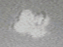
Stabilized, cropped view of Nellis S-30 UFO during close approach (2 miles). Note rotation, glowing multiple lobes, and shifting dark area. Object moving to right at about 200 miles per hour and climbing.
Stabilized, cropped view earlier in video when object is much further away. Note whitish "dome" on top, blackish triangular bottom initially, then the shape shifting to multiple fuzzy, then discrete whitish spherical lobes on the bottom with black core, then black side lobe. This also corresponded to period of high acceleration to high speed, followed by "coasting" upward in a steep climb.